
Monteverde Cloud Forest
Monteverde Visibility Index: [LIVE]
Live Visibility & Trail Guide
Is it a ‘Panorama Day’ or a ‘Misty Magic’ day?
Standard weather apps often fail in the Monteverde highlands because they pull data from the lower town of Santa Elena. Data506 provides a specialized Visibility Index measured at the Continental Divide (1,500m+). Use this real-time dashboard to determine if today is a ‘Panorama Day’ or a ‘Misty Magic’ day before you pay for your reserve entrance.
Live Satellite Tracking: Monteverde Cloud Movement
Our live satellite feed monitors the moisture-rich trade winds from the Caribbean as they collide with the Tilarán mountain range. Watch the white clusters moving from right to left; if they are dense over the Monteverde ridge, expect the famous ‘Pelo de Gato’ (fine mist) on the trails.
The "Hiking Expectation" Legend
| Visibility | Hike Status | What You'll See (Expectation vs. Reality) |
|---|---|---|
| 10km+ | 🟢 Crystal Clear | Rare 'Window' day. You can see the Gulf of Nicoya and the Pacific Ocean from La Ventana overlook. |
| 3km - 9km | 🟡 Cloud Peaks | Excellent for canopy photography. You’ll see the 'Elfin Forest' and giant ferns with high-altitude drifting clouds. |
| 500m - 2km | 🔵 Classic Mist | The quintessential Cloud Forest experience. Focus on macro shots of orchids, moss, and the Resplendent Quetzal. |
| <500m | ⚪ Whiteout | You are literally inside a cloud. Visibility is minimal; listen for the Three-Wattled Bellbird and enjoy the 'spooky' atmosphere. |
Pro-Tips for Your Monteverde Hike
-
The ‘Wind’ Factor: If the dashboard shows wind speeds above 20 km/h, the mist will move fast through the trees, perfect for time-lapse photography, but you’ll need a chin-strap for your hat!
-
What to Wear: Regardless of the visibility, always pack a light rain shell. At the Continental Divide, ‘Sunny’ can become ‘Soaked’ in under 10 minutes.
-
Trail Choice: On Whiteout days, skip the high-altitude viewpoints and stick to the Sendero Bosque Nuboso, the dense fog makes the ancient, twisted trees look incredibly mystical.
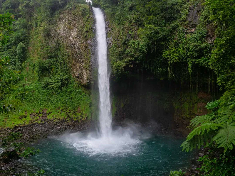
Catarata La Fortuna (The Waterfall)
-
500 steps to a 70-meter power-drop.
-
Arrival at 7:25am is mandatory to avoid the 8:30am tour bus surge. Water temperature stays a constant, refreshing 18°C (64°F).”
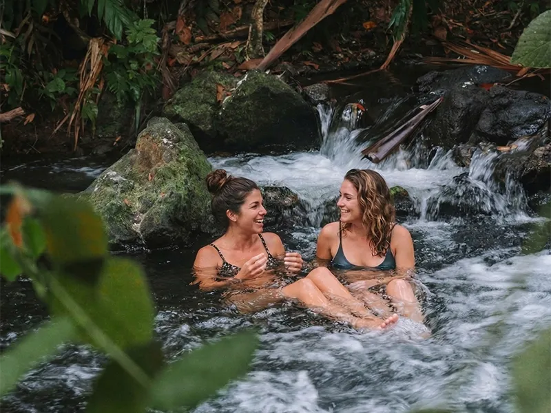
El Chollín River
-
Volcanic heat meets the river’s flow.
-
The ‘Free’ river (El Chollín) is 38°C (100°F). Pro tip: Wear water shoes; the rocks are volcanic and sharp. Paid resorts (Tabacón) cost $85+, but the river is the same water.
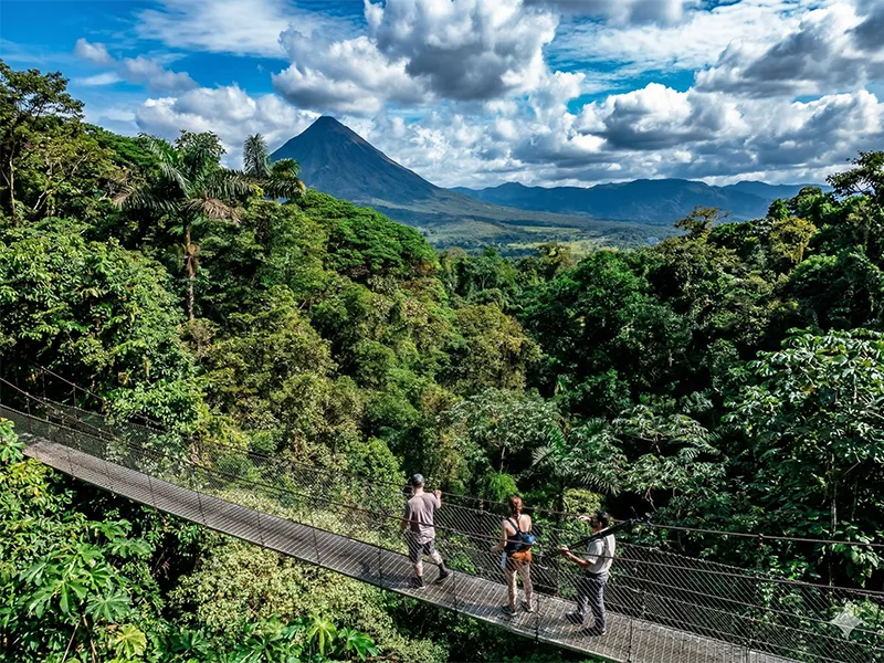
Mistico Hanging Bridges
- A 3.2km walk through the primary forest canopy.
- The 6 hanging bridges are up to 45 meters high. 6:00 AM slots have a 40% higher chance of sloth and Coati sightings compared to midday slots.
Monteverde sits at an elevation of 1,440 meters (4,724 ft). Because it is perched on the Tilarán mountain range, distances in kilometers don’t always translate to fast travel times. Expect winding, scenic roads that require a steady hand.
–
-
From San José (SJO Airport): 135 km | Drive Time: 2.5 to 3.5 hours.
-
Pro Tip: Use Route 27 to Route 1, then exit at Route 606 for the most paved experience.
-
-
To the Nearest Beach (Gulf of Nicoya): 50 km | Drive Time: 1.5 hours.
-
While you can see the ocean from the mountains, the descent to the coast is steep.
-
-
To La Fortuna (Arenal Volcano): 100 km | Drive Time: 3 to 4 hours.
-
The Shortcut: Ask about the “Jeep-Boat-Jeep” transfer. It’s the most iconic way to travel, crossing Lake Arenal by boat and cutting your travel time while adding a scenic tour.
-
-
To Manuel Antonio (Pacific Coast): 190 km | Drive Time: 4 to 4.5 hours.
-
This is the most common “Next Stop” for travelers moving from the cloud forest to the tropical beach.
-
Why is it called a “Cloud” Forest?
Unlike a Rainforest, a Cloud Forest receives much of its moisture directly from the clouds that “sit” on the trees. This constant immersion creates 100% humidity, allowing rare orchids and mosses to grow on every available inch of bark.
–
-
The Continental Divide: At the La Ventana viewpoint, you are standing on the spine of Central America. Drop a cup of water to the left, and it flows to the Pacific; drop it to the right, and it heads to the Caribbean.
-
A Birdwatcher’s Holy Grail: Monteverde is one of the best places on Earth to see the Resplendent Quetzal. These iridescent green birds were sacred to the Maya and Aztecs.
-
The Quaker Legacy: The reserve was originally protected in the 1950s by a group of Quakers from the US who moved here for peace and recognized the vital importance of protecting the watershed.